| Coastal Environment |
||
| Home
Abstract Project Motivation Coastal Environment
|
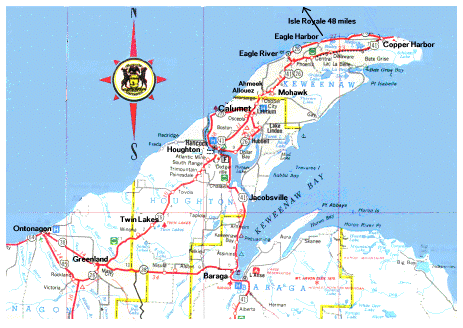
The Keweenaw Peninsula is a small arm of land that extends northeast into Lake Superior on Michigan’s Upper Peninsula. It is located on the south shore of the lake and is sparsely populated (<40,000 residents) and covers an area of about 1500 mi2.
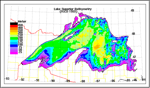
http://www.exploringthenorth.com/rocks/mapw.html Lake Superior is the largest of the Great Lakes and is one of the largest freshwater lakes in the world. It is not only covers an area of 31,700 mi2, but is also one of the deepest lakes in the world with depths reaching more than 400 m. Lake levels are controlled by the locks on the St. Mary's River in Sault Ste. Marie. The Lake itself is approximately 350 miles long and 160 miles wide. Because of its large volume, the retention time of the lake is about 191 years.
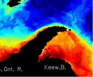
http://superior.eng.ohio-state.edu/lakes/superior/nf-index.html Since the Lake has a large surface area, the fetch, or distance wind travels along the surface of the water, is also quite large. This can result in the formation of large waves under the right meteorological conditions. Storm surges are common on Lake Superior, especially in the autumn months. Winds blowing across Lake Superior can come from all directions although the winds are usually dominated by northwesterly winds (40%) (Phillips, 1978). The bathymetry along the northwest shore of the Peninsula is quite steep. For example, the Lake reaches a depth of 200 m, 2 km off the coast of the northern half of the Peninsula near Eagle Harbor. This unique feature is also paralleled by a steep temperature gradient that extends 3-10 km from the shoreline. This environment supports the formation of a warm coastal current that flows in a northeastward direction along the north shore of the Keweenaw. This phenomena is known as the Keweenaw Current. Wind direction and speed strongly influence the current. Westerly winds intensify the current while easterly winds destroy it (VanLuven, 1999). The surface current velocity usually ranges from 0.5-1.0 m/s (Ragotzkie,1966). Because this is a warm water current, it has been captured in AVHRR images that mapped Lake Superior surface water tempuratures.
http://kites.chemistry.mtu.edu/KITES/picts/AVHRRcap.html It should also be noted that the shores of Lake Superior are less-developed than the shores of the other Great Lakes. Because much of the Lake Superior watershed is not developed or used for agricultural purposes, along with the Lake's great depth and cold temperatures, have resulted in an oligotrophic lake with low nutrient levels as well as low biological productivity.
|