|
||||
|
||||
|
Current Issues
 Figure 1 The South Shore breakwaters (Figure 2) are less sophisticated than the Harbor breakwaters. The 1.5 miles of structure are rubble mound breakwaters which protect the southern Milwaukee coastline. Openings in the breakwater structure allow vessels access to the shore. The gaps also allow for waves to diffract as they flow through, providing a calm harbor area. The stones used for construction have shifted in areas. This has caused a navigational danger in that some the rocks have slid into the access gaps. These rocks are often under water and not visible to those trying to navigate the gap in the breakwater.  Figure 2 STRUCTURE REHABILITATION In 1989, Milwaukee County completed the McKinley Beach Restoration Project. This provided a great deal of coastal area improvement, but did not include any breakwater improvement except the most northern piece of the structure. The USACE is currently studying rehabilitation needs. Read About It A feasibility study for the rehabilitation of the South Shore breakwaters was prepared by the USACE for the Milwaukee County of Public Works in May of 2001. The study considered first the potential reasons for movement of the breakwater rubble which has occurred (Figure 3). Movement could be due to forces resulting from ice formation, wave forces, structure settlement, inferior stone, and/or poor construction. The stones were not placed in an interlocking manner and are therefore susceptible to movement. The forces of ice formation add to the potential for stone movement. A combination of poor construction and ice formation has most likely caused the movement of the stones in the rubble mound. 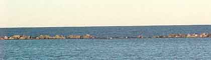 Figure 3 SHORELINE EROSION The bluff recession rate describes the amount of shoreline erosion which takes place. In 1990, the Lake Michigan Shoreline Erosion Management Plan determined the erosion material volume for approximately half of the Milwaukee coastline to be negligible with a bluff recession rate (1963-1985) of less than 0.5 feet/year. The remainder of the Milwaukee coastline was found to experience a bluff recession rate between 0.5 and 4.4 feet/year. This equates to approximately 100,000 cubic years of material per year eroded. Although this value seems rather large, it is an average over 20 years. Erosion is largely due to high water levels associated with storms. Most of the erosion likely took place during infrequent storms. The Lake Michigan Shoreline Erosion Management Plan of Milwaukee County states that "the Lake Michigan shoreline erosion problems of primary concern are storm damages to major harbor and lakefront structures, beaches, and facilities" (p.123). The 2001 South Shore Feasibility Study also considered shoreline erosion with respect to breakwater rehabilitation. Much of this coastline is comprised of vegetated bluffs ranging from 25 to 60 feet tall. The vegetation helps eliminate erosion activity. Although the breakwaters have deteriorated, they are still providing shore protection by dissipating much of the wave energy destined for shore. Parts of the shoreline where little beach area exists are also protected by riprap structures, helping alleviate erosion. Erosion that does occur in the coastline area of the South Shore appears to be due to surface run-off water into Lake Michigan, and not ineffective breakwaters. However, under high water level conditions, the breakwater structure does not adequately protect the shore from erosion. The high water overtops the breakwater and reaches the shore with greater erosion impacts. High water levels for storm surge in Milwaukee are provided with a recurrence interval. The recurrence interval equals the inverse of the percent probability that a high water level will occur. The recurrence interval = 100 years for 1% probability that storm surge level (+1.1-2.1 feet) exceeds mean water level (578.1 feet, NGVD 1929; 576.8, IGLD 1955; 577.5 feet, IGLD 1985; 176 meters, IGLD 1985). Wave run up heights are also addressed in the rehabilitation study of the breakwater structure. Surface water height from linear water wave set up (h) is found using the following: hs=4 x standard deviation This wave level is likely to be the highest water level set up by storms.  |
