 |
MILWAUKEE BREAKWATERS Cathy Moe 12/21/01 CEE514 |
| Home | Background | Issues | Improvements |
|
LOCATION |
 |
|
|
COASTAL ENVIRONMENT Understanding the various components of the coastal environment system is essential to the conscientious management of breakwaters as well as coastlines in general. The four components include the land, hydrodynamics, meteorology, and human activities associated with a coastal area. Geology, geomorphology, and vegetation are all issues relating to the land mass associated with a coastal area. The geology could be sandy beaches or rocky bluffs. Geomorphology describes the changing topography of land both above and below water. The existence of vegetation on a coastline helps reduce shoreline erosion. The hydrodynamics of the coastal environment system include the water level and wave action of a body of water. Changes in water levels are considered to be either long or short term. Long-term changes are generally due to variable amounts of precipitation. Annual mean water levels recorded by the USACE for Lake Michigan are shown in Figure 1. 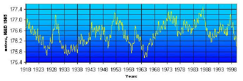 Short-term water level changes are due to storm surge (higher water level due to wind shear force across water), seiches (oscillation of water in a basin), wind-generated waves (wave run up), and tides (astronomical forces on water motion) (see Figure 2). Wave actions results from these sources as well. Changing water levels are a major cause of shoreline erosion and are an important factor considered today in the design of coastal structures.  The meteorology affecting an area can have many impacts, one of which is the effect on a coastal environment. Both the direction and speed of storm winds create high water levels and well as increased wave activity, as discussed above. Lastly, human activities have had the single greatest impact on coastal environment systems. Man has moved land to either extend the land area or create a water way for hundreds of years. Common activities associated with a coastal area include shipping and commerce, real estate development, leisure boating, fishing, and beach use. BREAKWATER HISTORY In 1920, just under two miles of the Milwaukee coastline was protected by breakwaters. By 1945, that length had increased to 5.5 miles. Since then, many smaller structures have been constructed closer to the coast, largely to protect Milwaukee's inner harbor. Portions of the Milwaukee Harbor breakwaters have been improved since initial construction. The McKinley Beach Restoration Project by Warzyn Engineering, Inc. (Lake Michigan Shoreline Erosion Plan) improved the coastal area at the northern end of Milwaukee Harbor. This project included some restructuring of the most northern piece of the Harbor breakwaters and was completed in 1989. The South Shore breakwaters were constructed in segments between 1913 and 1931. Since the initial construction, virtually no maintenance has been performed on the breakwater structure. Historically, most Great Lakes coastal structures were not designed with consideration for high water levels and wave heights. Hence, many structures have proven inadequate in wave energy dissipation and were in need of repair by the end of 20th century. Many studies have addressed issues regarding the effectiveness of the Milwaukee breakwaters, but few projects have actually been undertaken. Currently, studies considering improvements and rehabilitation of both major Milwaukee breakwater structures are taking place. New design is based on a 100 year water level and a 20 year storm, instead of the previous guidelines of a 20 year water level and 10 year storm. |
||
