|
Bathymetry Techniques and a Study of Little Sand Bay Harbor in Lake Superior, WI |
|
Introduction to the Problem
According to the National Oceanic and Atmospheric Administration (NOAA), water levels in Lake Superior have dropped to record low levels. On August 16, 2007, NOAA hydrologists reported that the level of Lake Superior was 183.028 meters, less than 0.1 meter above the record low level for September of 183.06 meters, set in 1926.
The lower water levels greatly impact the shipping industry, which relies on Great Lakes waterway to transport cargo to and from major ports such as Montreal, Detroit, Duluth and Milwaukee. According to NOAA, cargo ships must reduce their loads by 50 to 270 tons for every inch decrease in the water level. The economic impact of reduced cargo eventually is carried onto the product consumers.
To reduce the impact of lower water levels, harbors and marinas must consider the cost-benefits of dredging, relocating, or closing down.
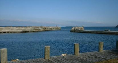
Little Sand Bay Harbor, part of the Apostle Islands National Lakeshore in Northern Wisconsin, lies on the coast of Lake Superior. The National Park Service dredges Little Sand Bay Harbor every few years, to provide tourists with a launch point for a variety of recreational activities (kayaking, sailing, boating, fishing, etc).
To prepare for dredging and to analyze the effectiveness of the current harbor, it is necessary to determine the bathymetry inside and outside of the harbor.
|
|
Jerry J. Wilke CEE 514: Coastal Engineering University of Wisconsin –Madison Department of Civil and Environmental Engineering |
|
Motivation for Reviewing Bathymetry Techniques
With coastal engineering, there are two environmental conditions essential to analysis: wave characteristics (wave period, offshore wave height, wavelength, angle of approach, etc) and bathymetry/coastal structures (depth contours, slope, reflection coefficient, etc). Knowing the water depth and understanding how it changes with location is critical to interpreting many coastal processes, such as wave shoaling and refraction. Bathymetry is needed in estimating wave height, locating breakwaters, and designing other models.
From the experiences gained in CEE 514: Coastal Engineering, it became evident that bathymetry mapping is an arduous process. Thoughtful commitment is required to both measure and record water depths over a body of water accurately, and careful analysis is needed to create detailed contours.
First, I asked, “Is there a better way to obtain this data, or manage it, so there isn’t so much processing?” Second, I wondered what would be the best means to develop a contour. Through this project, I hope to answer these questions, and provide a step-by-step approach for future coastal engineers to begin creating a bathymetry map. |
|
Contact Me at jwilke1@wisc.edu |
|
|
University of Wisconsin-Madison Department of Civil and Environmental Engineering |