INTRODUCTION
AREA OF CONCERN
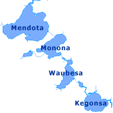
Lake Monona is a freshwater drainage lake in Dane County, Wisconsin surrounded on three sides by the city of Madison, Wisconsin and on the south side by the city of Monona, Wisconsin. It is the second-largest of a chain of four lakes along the Yahara River. The Yahara River also includes lakes Mendota, Kegonsa, and Waubesa. Lake Monona is regulated by locks in the Yahara River exiting Lake Mendota. Lake Monona is fed by three tributaries which include the Yahara River (from Lake Mendota), Starkweather Creek, and Wingra Creek.
Lake Monona Characteristics
Location 43°4′9″N, 89°21′34″W
Surface Area 3,274 acres (13.2 km²)
Mean depth 27 ft (8 m)
Maximum depth 64 ft (20 m)
Volume 28 billion US gallons (110,000,000 m³)
Shoreline length 13 miles (21 km)
Lake Elevation 845 feet
REASON FOR CONCERN
Stormwater runoff is a large factor in water quality as it transports sediment, bacteria, oil, fertilizer, and etc. to Monona Bay. Additionally, there are an abundance of lake weeds that are fed by nutrients in the water and bottom sediment. Also, algae blooms are prevalent in the summer due to high levels of phosphorus. There is a lack of understanding of the circulation patterns that affect the extent, timing, and direction of exchange to and from Lake Monona and Monona Bay. Mathematical models using site-specific data is instrumental in understanding the exchanges. After analyzing mathematical models, can decisions regarding long term projects for Monona Bay be made.
CIRCULATION
Circulation of water transports sediments, dissolved oxygen, minerals and nutrients throughout the bay and the lake proper. Positive circulation is essential and is a concern as some areas can develop stagnant or "dead spots". Water movement also discourages algae, and promotes fish health. Circulation is driven primarily by the movements of stormwater discharges and wind. Circulation causes nutrients and sediments to be mixed and resuspended. Wind also plays a role in the mixing of the bay's waters. The wind can also raise or lower the level of surface waters but in Monona Bay this effect is negligible. It is necessary to understand the circulation process and how the transfer rate is defined from Monona Bay to Lake Monona or vice versa.