Indian Ocean Tsunami
Calculating Tsunami Run-Up Height
Sylvia Wijaya
CEE 514 – Coastal Engineering
Facts
In this section, several facts from the Indian Ocean tsunami are provided.
1. Magnitude and Location of Earthquake
The earthquake was estimated to be 9.3 at Richter scale. The hypocenter of the main earthquake was at 3.16 oN, 95.854 oE, 160 km (100 mil)e west of Sumatra at depth 30 km (18.6 mile) below meant sea level. The earthquake occurred at the western end of the Ring of Fire, the earthquake belt that accounts for 81% of the world’s largest earthquakes. The Indonesian region is one of the most seismically active zones of the earth; at the same time it has a leading position from the point of view of active and potentially active volcanoes. The earthquake occurred on the interface of India and Burma plates and was caused by the release of stresses developed as the Burma plate overrode the Inidan plate. In the region of the earthquake, the India plate moves toward the northeast at a rate of about 6 cm/year relative to the Burma plate. This results in oblique convergence at the Sunda trench. The oblique motion is partitioned into thrust-faulting, which occurs on the plate-interface. The Indian Ocean earthquake occurred as the result of thrust-faulting.
2. Power Generated by the Tsunami
The total energy released by Indian Ocean tsunami is estimated as 3.35 × 10 18 Joules. The earthquake is also estimated to have resulted in an oscillation of the earth’s surface of about 20-30 cm, equivalent to the effect of the tidal forces caused by the sun and moon. The shift of mass and the massive release of energy very slightly altered the Earth's rotation. The theoretical models suggest the earthquake shortened the length of a day by 2.68 microseconds (2.68 µs) (or about one billionth of the length of a day) due to a decrease in the oblateness of the Earth. However, due to tidal effects of the moon, the length of a day increases at an average of 15 µs per year, so any rotational change due to the earthquake will be lost quickly. There were also 10 m (33 ft) movement laterally and 4 to 5 m (13 to 16 ft) vertically along the fault line. Early speculation was that some of the smaller islands southwest of Sumatra may have moved southwest by up to 20 m (66 ft). There were also calculations that the northern tip of Sumatra, which is on the Burma Plate (the southern regions are on the Sunda Plate), may have moved up to 36 m (118 ft) southwest. Since movement was vertical as well as lateral, some coastal areas may now be below sea level.
3. Death Toll
In December 26 earthquake, the tsunami reached a height of 24 m (80ft) when arriving at the coastline, rising to even 30 m (100ft) in some areas when traveling inland.
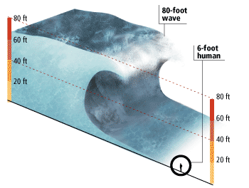
Figure 7: The comparison between tsunami wave height and human height.
Country Affected |
Deaths |
Missing |
Indonesia |
163,978 |
37,063 |
Sri Lanka |
30,957 |
5,637 |
India |
10,749 |
5,640 |
Thailand |
5,395 |
2,932 |
Somalia |
298 |
- |
Myanmar ( Burma) |
61 |
200 |
Malaysia |
68 |
300 |
Maldives |
82 |
61 |
Seychelles |
3 |
- |
Tanzania |
10 |
- |
Bangladesh |
2 |
- |
South Africa |
2 |
- |
Kenya |
1 |
- |
Yemen |
2 |
- |
Madagascar |
- |
- |
Table 1: The death and missing tolls from various affected countries.
4. Environmental Impact
Apart from the enormous death toll, the tsunami has also cause severe damage on ecosystems such as mangroves, coral reefs, forest, coastal wetlands, etc. Other damage is also caused by the poisoning of the fresh water and the soil by the salt water infiltration and deposit of salt layer land.
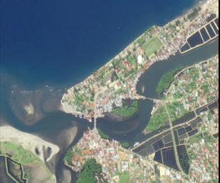
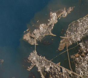
Figure 8: Pictures of pre and post tsunami at Aceh, Indonesia coastline.
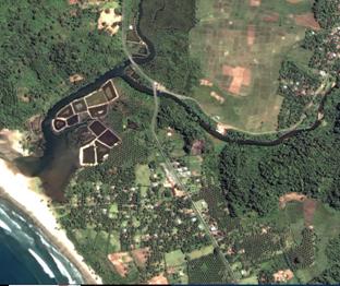
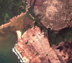
Figure 9: Another pictures of pre and post tsunami at Aceh, Indonesia coastline.