Eutrophication caused by excessive inputs of nutrients, i.e., phosphorus and nitrogen, is a growing water quality problem in rivers, lakes and estuaries. Runoff from both rural (fertilizer and manure) and urban (urbanizing landscapes and uncontrolled storm sewer outfalls) would increase source loadings. Watershed Adaptive Management (WAM), a regulatory approach, can put a premium on all parties working together to improve water quality. WAM in a natural resource context can involve learning from the outcomes, either expected or unexpected of implementing actions. For example the WAM Option is a provision of Wisconsin’s phosphorus rule. As a result certain sewerage districts around the state can have an alternative path to reduce phosphorus levels in surface waters, required to do by the Clean Water Act – instead of removing phosphorus exclusively through technology at treatment plants. In other words, some attempt can be made to keep phosphorus out of the water in the first place. One challenging task is to develop an effective water quality monitoring strategy that can document whether progress in reducing phosphorus is being made. To achieve this goal, we are currently developing a watershed model that can be used to address field scale changes for adaptive management in the Yahara watershed. Specifically we would employ unstructured/TIN grids to delineate detailed spatial information (digital elevation model, soil type and land use), in contrast to traditional watershed delineation methods. Furthermore to effectively monitor success or issues of the WAM for regulating external nutrient loading sources, we integrate the new unstructured/TIN watershed model into the INFOS-Yahara Lakes cyber-infrastructure. The integrated watershed and INFOS Yahara can provide us with critical information for agencies/stakeholders to decide how to make informed decisions on regulations and allocate strategies for cost sharing.


Bioavailable Phosphorus and Sediment Dynamics in Stream Pools/Wetlands in Lake Watersheds
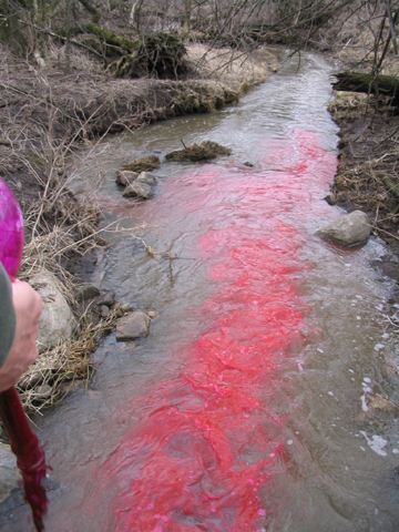
Agricultural inputs of
phosphorus are major contributors of nonpoint source
pollution to surface water bodies. Increased attention has
recently been focused on the differentiation between total
phosphorus and the portion that is actually
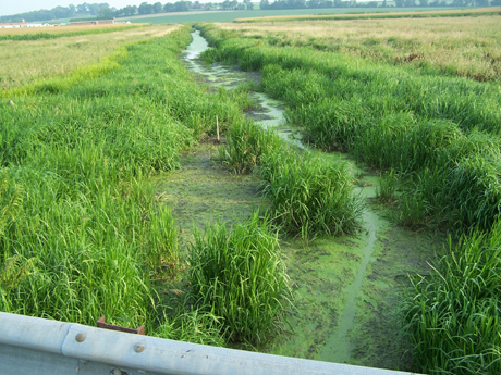
“bioavailable”. Streambed/Pool sediments have been shown
to be the main storage of phosphorus released from
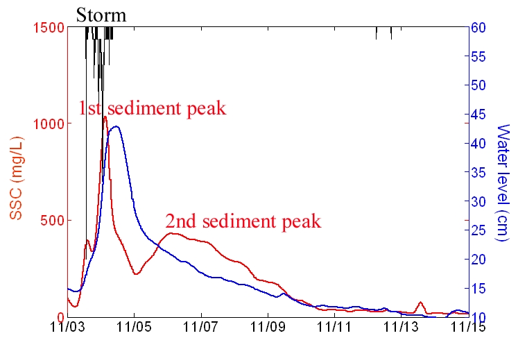
watersheds. It is believed that hydrodynamic processes
play an important role in causing sediment resuspension,
deposition, mixing, and advective and diffusive transport
in the pools. Other factors such as the grasses,
and plant material in the instream deposits and bank
materials can also contribute to the erosion resistance of
the channel material and are source of phosphorus. We are
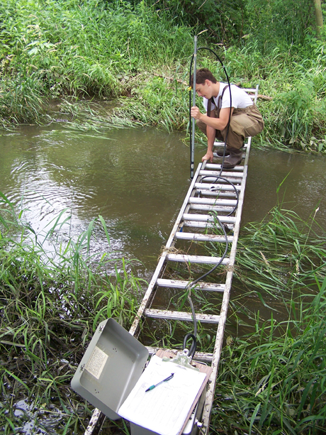
investigating the effects of hydrodynamic processes and
physicochemical factors on the mobility of sediments in
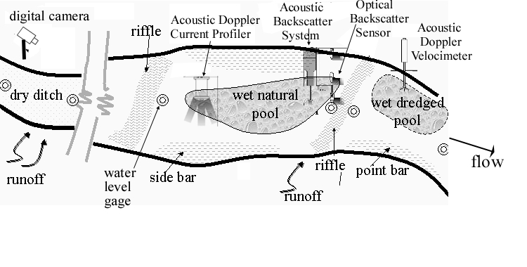
the Yahara River and its tributaries. Both field
experiments and modeling in different type of pools (dry
ditch, wet natural pool, and wet dredged pool) are
conducted by our interdisciplinary research team.
Our final goal is to elucidate and quantify the in-stream
processes governing the fate and transport of bioavailable
phosphorus in channels and streams sediments.
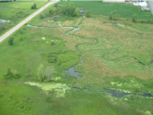
Wetlands are unique features of the
landscape that can significantly affect the movement and
quality of surface and ground waters. By temporarily
storing water, wetlands can reduce flood peaks, sustain
streamflow during dry periods, retain sediment and
phosphorus, and promote denitrification. But throughout
most of human history, wetlands have been considered
"wastelands" and many have been drained for agriculture
and other uses. For example, over 60 percent of the
wetlands that once existed in the Midwestern U.S. have
been lost, mostly to agricultural uses. Many of the
remaining wetlands have been degraded, largely through
ditching and channel incision. These degraded wetlands are
predominantly located in agricultural areas where surface
water quality is severely impaired by excessive sediment
and nutrient loads. Despite their prevalence, little is
known about the degree to which these degraded wetlands
mitigate this impairment. This project is aimed to better
understand the role of wetlands in controlling water
quantity and quality through a nested modeling approach
and field validation.
Sponsor : US-EPA/USDA
City of Madison, WI
Wisconsin Department of Natural Resources
Dane County Land and Water
Resources Department
Status : Active
Openings
Student Investigators: Xi Chen (MS), John
Reimer (PhD)
Graduated: Owen Zhu (MS), Gary Guo (MS), Justin Roger (MS), Evan Murdock (MS), Doo-Yong Choi (PhD)
Publications:
- Guo, G., Wu, C.H., and Reimer, J.R., A multiple-time-scale approach to SWAT in urbanizing watersheds:development and application, to be submitted.
- Zhu, Y., Reimer, J.R., Wu, C.H., 2015. Field-Scale
Phosphorus Loading Assessment: Development and
Application of TIN-Based SWAT Model, Best
Student Poster Award , AWRA, 2015.
- Rogers, J. S. Potter, K.W., Hoffman, A.R., Hoopes, J.A, Wu, C.H., and Armstrong, D.E. Hydrologic and water quality functions of a small wetland, J. of the American Water Resources Association, 45 (3), 628-640, 2009.
- Rogers, Justin M., Hydrologic and Water Quality Characteristics of a Small Wetland- Upper Dorn Creek Wetland, Wisconsin. Master Thesis, Dept. of Civil and Environmental Engineering, UW-Madison, 2006.
- Choi, D.Y., An non-hydrostatic model in open channel flows, Ph.D. Dissertation, Dept. of Civil and Environmental Engineering, UW-Madison, 2006.
- Evan Murdock, Transport and storage of sediments and solutes in a small agricultural stream, Dane County, Wisconsin, Master Thesis, Dept. of Civil and Environmental Engineering, UW-Madison, 2005.