Risk Assessment
and Sustainable Remediation of Contaminated
Sediments
Contaminated sediments can cause serious water quality problems. For example the Laurentian Great Lakes contain nearly 20% of the world’s surface freshwater. More that 30 million people live in the Great Lakes basin. Many contaminants in the Great Lakes, such as Polychlorinated biphenyls (PCBs), are both persistent in the aquatic system and strongly associated with various sediments. In this research theme, we assist to conduct risk assessment of the fate and transport of contaminated sediments. Furthermore our task is to provide sustainable remediation plan of contaminated sediments.


ASETS erosion system Sediment cores Bottom Erosion and Deposition (BEDS) Side-Scan Sonar Map
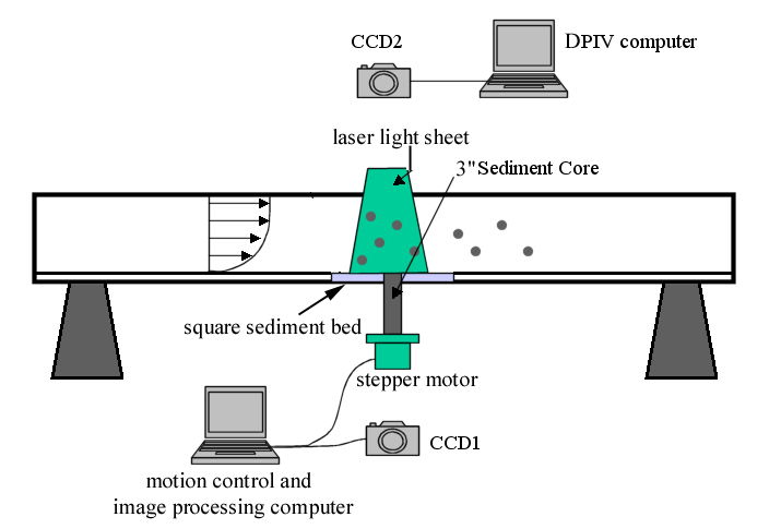
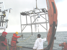
Fundamental understanding coastal and riverine processes responsible for the resuspension, transport, and deposition of contaminated sediment, the cycling of pollutants, and biological productivity in the Great Lakes or inland lakes is critical. Given the long water retention time and yet highly dynamic characteristics, the Great Lakes and their estuaries are typified by a low sedimentation rate. Contaminated sediment can be resuspended under a variety of external forces, including high river flows, waves, or lake seiches. Both laboratory methods and in-situ methods have been developed and employed to obtain erosion conditions, i.e., critical bed shear stress and sediment erosion rate. An innovative and cost-effective laboratory method using an open channel tilting flume with an automatic piston-image system, digital particle image velocimetry (DPIV), and optical backscatter sensors was developed to obtain the critical shear stress and erosion rate for sediment bed cores. Most in-situ methods utilize flow past through a straight, annular or radial flume to measure erosion rates. Questions regarding the ability of these methods to correctly represent natural flow conditions remain. We are developing an in-situ Bottom Erosion and Deposition System (BEDS), which consists of an acoustic Doppler velocimetry (ADV) to measure 3-dimensional bottom turbulence at one point; two pulse to pulse, coherent, acoustic Doppler current profilers (ADCPs) to measure the mean and turbulent velocity bottom profiles; five optical back scattering sensors (OBS) and a laser in-situ scattering and transmissometry (LISST-ST) and a three-frequency, acoustic backscatter system (ABS) to measure settling velocity, concentration profiles of fine and coarse sediments, and an automated stereo-imaging system (ASIS) to measure bottom sediment evolution. BEDS has been deployed in several Area of Concerns (AOC) in Lake Michigan. Results show that waves can play an important role in resuspension sediments, which can erode to the depth where contaminants, i.e. PCB, are mostly located. In recent years, we have been developing a combined geophysical technique, based upon acoustic-wave based sub-bottom profiler (SBP) and electromagnetic-wave based ground penetrating radar (GPR), to map bathymetry and sediment sublayers. In areas with high silt and clay contents, SBP is able to image the sediment sublayers, whereas in the areas with sand cover and vegetation, GPR provides sediment stratigraphic information. In addition we use Shelby tubes and hydraulic jetting to collect ground-truth information so that we can accurately to map sublayer thicknesses based upon a mixture-based equation. The technique allows us to effectively map three-dimensional contaminated subbottom sediments, which is valuable to remediation.
Sponsor :
Cooperative Institute for Limnology and Ecosystems Research, NOAA
Great Lakes Environmental Research Laboratory, NOAA
Great Lakes Restoration Initiative
USEPA
US Army Corps of Engineers
University of Wisconsin Sea Grant Institute, NOAA
Wisconsin Department of Natural Resources
Wisconsin Alumni Research Foundation
Status : Active
Student Investigators:
Alvaro Linares (PhD)
Graduated: Josh Anderson (PhD), Kevin Lin (PhD), Cheegwan Lee (PhD), Lauren Seabury (MS)
Collaborators:
Dr. Eric Anderson, NOAA, Great Lakes Environmental Research Laboratory
Dr. Philip Chu, NOAA, Great Lakes Environmental Research Laboratory
Professor Jim Hurley, Civil and Environmental Engineering, UW-Madison
Professor Dante Fratta, Civil and Environmental Engineering, UW-Madison
Professor John Hoopes, Civil and Environmental Engineering, UW-Madison
Dr. Xiaochun Zhang, Wisconsin Department of Natural Resources
Publications:
- Anderson, J.D., Linares, A., and Wu, C.H., The role of
high frequency fluctuations on bed shear stress in the
lower Sheboygan River, Lake Michigan, submitted, 2018.
- Linares, A., Wu, C.H., Anderson, J.A., Chu,
P.Y., Role of meteorologically-induced water level
oscillations on bottom shear stress in freshwater
estuaries in the Great Lakes, J. Geophysical
Research-Oceans, 123 (7), 4970-4987, 2018.
- Lin, Y.. T, Wu, C.H., Fratta, D., Kung, K.-J.S.,
Integrated acoustic and electromagnetic wave-based
technique to estimate subbottom sediment properties in
aquatic environment, Near Surface Geophysics,
8(3), 213-221, 2010.
- Lin, Y.T., Schuettpelz, C., Wu, C.H., and Fratta, D.,
A., combined acoustic and electromagnetic wave-based
technique for bathymetry and subbottom profiling in
shallow waters. Journal of Applied Geophysics,
68, 203-219, 2009.
- Lee, C., Wu, C.H., and Hoopes, J.A., Simultaneous particle size and concentration measurements by a back-lighted particle imaging system, Flow Measurement and Instrumentation, 20, 189-199, 2009.
- Ng, C.O. and Wu, C.H., Dispersion of suspended
particles in a wave boundary layer over a viscoelastic
bed. International J. of Engineering Science
46, 50-65 2008.
- Lee, C., Wu, C.H. and J.A. Hoopes. Automated sediment erosion testing system using digital imaging, J. Hydraulic Engineering-ASCE, 130, 8, 771-781, 2004.
Back