Inland Lakes
Blooms of blue-green algae (i.e. cyanobacteria) are temporally and spatially variable in eutrophic lakes. Algal species that constitute the blooms are also highly variable and sub-species characteristics of algae differ widely (e.g., clumping vs. non-clumping or toxin-producing vs. non-toxin producing genotypes). Because blue-green algae are often buoyant, hydrodynamic processes result in large intra-lake spatial variability in algal abundance with the potential for high inter-lake spatial correlation in bloom patterns including noxious bloom pile-ups on downwind shorelines. As a result all these factors, the ecological and public health consequences of blue-green algal blooms can be major.
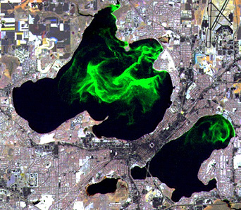
An interdisciplinary approach will be used to characterize spatial/temporal dynamics of bloom development. For remote sensing technologies, we are currently developing a remote controlled model aircraft (DigiDot2) with a high precision CCD camera to sample across the lake. In addition, we are developing a real-time water imaging system (RTWIS) with aerial photogrammetry technique for monitoring water quality in eutrophic lakes under various biophysical environment. At the lake district scale, IKONOS, QuickBird, SPOT, and Landsat will be used to study blooms on lakes. To acquire in-situ and real-time data, a state-of-the-art wireless buoy, vertical profiling buoy, and the BEDS are used to measure nutrients, phytoplankton and zooplankton species densities, velocity and temperature profiles. Molecular characterization of cyanobacterial taxa are used to detect community change in response to in-situ and remote chemical and physical measurements. Some on-going research progress can be found at the Lake Mendota Environmental Observatory website. Our interdisciplinary approach allows us to assess algal bloom as the synchronicity of bloom development among lakes and the spatial variability of such external drivers as weather or climate change.
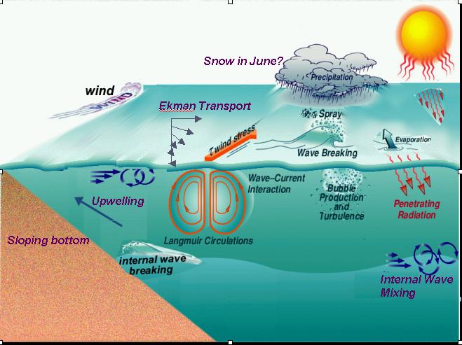
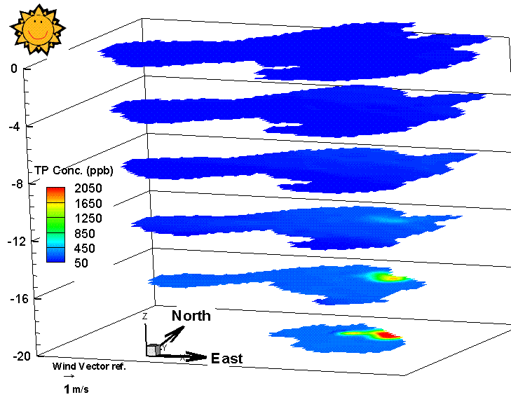
Ongoing research themes address multiple aspects of water quantity and quality that are of great concerns and interests of the local authorities and Wisconsin citizens. For example one potential strategy for managing the Yahara River watershed is to maintain the hydrological budget by discharging treated effluent released from a water treatment plant. The goal is to evaluate the water levels and examine the fate of hypolimnetic effluent discharges. Specific tasks include: (i) hydrology and hydrodynamics of the lake; (ii) fate and transport of phosphorus in the lake; and (iii) the composition and phosphorus-liberating activity of the lake bacterial communities. We are developing a three-dimensional non-hydrostatic and stratified flow model (3DNHYS) to examine general circulation pattern, surface and internal waves and their breaking over shoaling bathymetry. The model would take into account of the effects of of temperature stratification, steep bathymetry, and wave-current interactions. In addition, the 3DNYHS model is coupled with a water quality model to examine the environmental impacts of LTER Lakes. The integrated model shows that discharge effluents would be trapped within the hyperlimnion during the summer season but could escape through the thermocline under a storm event.
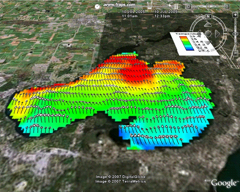
Another on-going research is the development of the Integrated Nowcast and Forecast Operation System (INFOS) that provides real-time measured and modeling water information for the Yahara Lakes. The effects of hydrologic, hydrodynamic and wind wave characteristics on environmental impacts of Madison Lakes such as flooding, sediment deposition, and shoreline erosion have been concerns and interests of the local authorities and Wisconsin citizens. INFOS is a community online web platform that shows real-time data including water level, discharge, temperature, and other meteorological measurements. INFOS integrates observations into models to provide spatial variation of water parameters and transport of sediments and nutrients. The present stage and future stage of lake information will be posted through the web using nowcasting and forecasting models. Our overall goal is to provide managers and researchers to assess the water levels and nutrient management strategies for the Yahara Lakes system.
Great Lakes
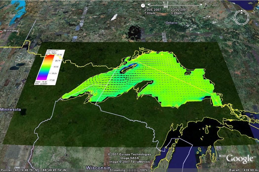
Lake Superior circulation in Google-earth
Wireless real-time buoy and nowcast
modeling
Generations of meteotsunamis
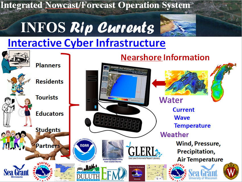
INFOS-Rip Current
We have been working several projects on the
Laurentian Great Lakes. During the past several years, We
attempt to close the carbon budget for one of the Great
Lakes using numerical models and data. An interdisciplinary
team aims to develop reliable estimates of
lake-atmosphere CO2 fluxes on seasonal to decadal
timescales and to identify key uncertainties in the carbon
budget of Lake Superior. Additionally, this project will
contribute to efforts led by terrestrial carbon cycle
scientists to understand the regional carbon budget.
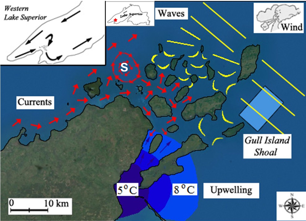
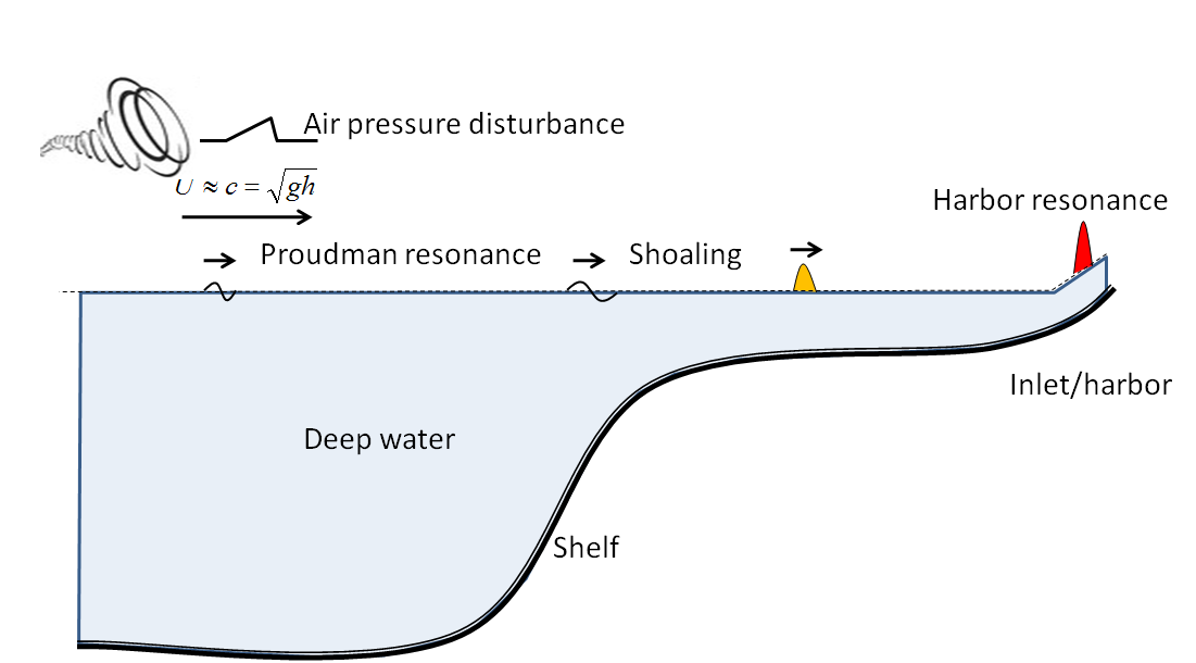
Meteotsunamis can pose a serious threat to the Lake Michigan coast, owing to the lake’s characteristics that facilitate the formation of destructive meteotsunamis including frequent fast-moving storm fronts, resonance-promoting bathymetry, and harbors to finally amplify the wave. The most vivid historical meteotsunami on record in the Great Lakes occurred in 1954, when a squall line-induced longwave wave struck Chicago in Lake Michigan. The coast was inundated up to 50 meters inland and unexpectedly swept many fishermen off of the Montrose Harbor piers, killing seven. While the threat of meteotsunamis in Lake Michigan has been recognized, to date no infrastructure for detecting and warning of a pending meteotsunami disaster is available. Furthermore the potential hot spots in Lake Michigan that can be threatened by meteotsunamis has yet been identified and characterized. In collaboration researchers in Great Lakes Environmental Research Laboratory, we are currently implementing an observation network system to better understand the occurrence of meterotsunamis. An operational meteotsunami forecasting and warning system is also being developed to keep residents safe and avoid dangerous events.
| Rip
currents are shore-normal, rapid seaward
flows that originate in the surf zone. As a hidden
but lethal hazard at Great
Lakes beaches, rip currents can quickly sweep
swimmers away from the shore out to the open, deep
water. It has been estimated by the Great
Lakes Current Incident Database that every
summer an average 12 fatalities and 26 rescues are
related to rip currents during from 2002 to 2012.
Rip currents sometimes are incorrectly referred as “undertows”
or “rip tides”; however, those are three
different phenomena. Undertow is the backwash
of breaking waves and in general a weak flow. On the
other hand, rip tides are strong offshore currents
caused by the constricted tidal flow through barrier
beaches. In comparison, rip currents are strong,
non-periodical, discretely located, and more
dangerous than the other two types of offshore
currents. Rip currents are in general caused by
spatial difference in wave breaking along the
shoreline; however, the mechanism for generation of
rip current can be complicated and varies on a
beach-to-beach basis. To improve beach hazard
rip-current warning, we will develop an
Integrated Nowcast (real-time) Observation and
Forecast (future) Operation System (INFOS) and
applying the INFOS at three rip-current prone
beaches through coordination, communication, and
community outreach and education. The three beaches,
(i) Park Point Beach, Duluth, MN, (ii) Bradford
Beach, Milwaukee, WI, and (iii) North Beach, Port
Washington, WI, are identified as high occurrence of
bar-gap, headland, and structured-induced rip
currents, respectively. The proposed project is an
integrated and collaborative effort among many
partners: UW-Madison, Minnesota/Wisconsin Sea
Grants, Wisconsin Coastal Management Program,
National Weather Service at Duluth and
Milwaukee/Sullivan, City of Duluth, Milwaukee
County, and City of Port Washington, NOAA-NOS
and Great Lakes Environmental Research Laboratory.
Several news related to the INFOS-rip current
project can be accessed here. |
Arthur H. Frazier Fellowship
City of Madison, WI
Coastal Storm Program, NOAA - Ohio Sea Grant College Program
Cooperative Institute for Limnology and Ecosystems Research
Dane County Land and Water Resources Department
Gordon and Betty Moore Foundation
Hilldale Undergraduate/Faculty Research Fellowships
Madison Metropolitan Sewerage District
NOAA-Ocean and Human Health
NSF-North Temperate Lakes Long-Term Ecological Research
NSF-Ocean Sciences
NSF-Environmental Biology
Office of Sustainability SIRE Award Program
University of Wisconsin Sea Grant Institute, NOAA
UW-Madison/UW-Milwaukee Intercampus Research Incentive Grants Program
University of Wisconsin Water Resources Institute
Wisconsin Alumni Research Foundation
Wisconsin Coastal Management Program, NOAA
Status : Active
Student Investigators:
John Reimer (PhD), Yuli Liu (PhD), Wei Wang (PhD), Michael Meyer (MS), Chen Jin (MS)
Graduated: Josh Anderson (PhD), Madeline Magee (PhD), Adam Bechle (PhD), Jordan Read (PhD), Yi-Fang Hsieh (PhD), C.C. Jay Young (PhD),
Nobuaki Kimura (PhD), Henry Yuan (PhD), Dong Yong Choi (PhD),
Prashansa Shrivastava (MS), Biyun Sheng (MS), Anastasia Gunawan (MS), Hoi Lai Tseung (MS), Sen Yan (MS),
Khurran Khan (MS), John Reimer (MS), Theresa Possley (MS)
Openings
Collaborators:
Dr. Eric Anderson, NOAA, Great Lakes Environmental Research Laboratory
Mr. Todd Breiby, Wisconsin Coastal Management Program
Professor Steven Carpenter, Center of Limnology, UW-Madison
Mr. Gene Clark, Coastal Engineering Specialist, NOAA-UW Sea Grant Institute
Professor Ankur Desai, AOS, UW-Madison
Professor Paul Hanson, Center of Limnology, UW-Madison
Dr. Jane Harrison, Social Science Specialist, NOAA-UW Sea Grant Institute
Dr. John Kelley, NOAA/National Ocean Service
Dr. Tim Kratz, Center of Limnology, UW-Madison
Professor David Hamilton, University of Waikato, New Zealand
Dr. Richard (Dick) Lathrop, WDNR/Center of Limnology, UW-Madison
Professor Trina McMahon, CEE/Bacteriology, UW-Madison
Dr. Alexander B. Rabinovich, P.P. Shirshov Institute of Oceanology, Russian Academy of Sciences
Professor Galen Mckinley, AOS, UW-Madison
Dr. Dale Robertson, USGS, Wisconsin
Mr. Jesse Schomberg, Minnesota Sea Grant
Dr. David Schwab, Graham Sustainability Institute, University of Michigan
Dr. Joseph Zhang, Virginia Institute of Marine Science
Publications:
- Zhang, Y.J.,Wu, C.H., Anderson, J.D., Danilov, S.,
Wang, Q., Liu, Y., Qang, Q., Lake ice simulation using a
3D unstructured grid model, Ocean Dynamics, 73, 219-230,
https://doi.org/10.1007/s10236-023-01549-9,
2023.
- Linares, A., Wu, C.H., Bechle, A.J., Anderson, J.A., and Kristovich, D.A, Unexpected rip currents induced by a meteotsunami, Scientific Reports, doi:10.1038/s41598-019-38716-2, 2019.
- Magee, M.R, McIntyre, P.B., Hanson, P.C., and Wu,
C.H., Drivers and management implications of long-term
cisco oxythermal habitat decline in Lake Mendota,
WI. Environmental Management, doi:10.1007/s00267-018-01134-7,
2019.
- Kimura, N. and Wu, C.H., Using a nowcasting system to
understand lake water dynamics, Lakes &
Reservoirs: Science, Policy and Management for
Sustainable Use, 23(4), 367-380, doi:10.1111/lre.12239,
2018.
- Anderson, J.D. and Wu, C.H., Development and Application of a real-time water environment cyber-infrastructure for kayaker safety in the Apostle Islands, Lake Superior, Lake Superior. J. of Great Lakes Research, 44 (5), 990-1001, doi.org/10.1016/j.jglr.2018.07.006, 2018.
- Magee, M., McIntyre, P.B., and Wu, C.H., 2018, Modeling oxythermal stress for cool-water fishes in lakes using a cumulative dosage approach, Canadian Journal of Fisheries and Aquatic Sciences, 75(8), 1303-1312, doi.org/10.1139/cjfas-2017-0260.
- Linares, A., Wu, C.H., Anderson, J.A., Chu, P.Y., Role of meteorologically-induced water level oscillations on bottom shear stress in freshwater estuaries in the Great Lakes, J. Geophysical Research-Oceans, 123 (7), 4970-4987, doi.org/10.1029/2017JC013741, 2018.
- Hamilton, D.P., Magee, M.R., Wu, C.H., Kratz, T. K.,
Ice cover and thermal regime in a dimictic seepage lake
under climate change, Inland Waters, 8(3),
381-398,
doi/full/10.1080/20442041.2018.1505372, 2018.
- Magee, M. and Wu, C.H.,
Response of water temperatures and stratification to
changing climate in three lakes with different
morphometry, Hydrology and Earth System Sciences,
21(12), 6253-6274,
2017.
- Magee, M. and Wu, C.H., Effects of changing climate on ice cover in three morphometrically different lakes, Hydrological Processes, 31(2), 308-323, 2017.
- Bechle, A.J., Wu, C.H., David A.R. Kristovich, D.A., Anderson, E.J., Schwab, D.J., Rabinovich, A.B., Meteotsunamis in the Laurentian Great Lakes, Scientific Reports, 6, 37832, doi:10.1038/srep37832, 2016.
- Linares, A., Bechle, A.J., and Wu,C.H.,
Characterization and Assessment of the meteotsunami
hazard in northern Lake Michigan, J. Geophysical
Research-Oceans, 121(9), 7141–7158
,
2016.
- Kimura, N., Wu, C.H., Hoopes, J.A., and Tai, A. Diurnal thermal dynamic processes in a small and shallow lake under non-uniform wind and weak stratification, Journal of Hydraulic Engineering-ASCE, 142(11), 04016047, 10.1061/(ASCE)HY.1943-7900.0001190, 2016.
- Magee, M.R., Wu, C.H., Robertson, D.M., Lathrop, R.C., and Hamilton, D.P. Trends and abrupt changes in 104-years of ice cover and water temperature in a dimictic lake in response to air temperature, wind speed, and water clarity drivers, Hydrology and Earth System Sciences, 20(5), 1681-1702, 2016.
- Bechle, A.J., Kristovich, D.A, and Wu, C.H.,
Meteotsunami Occurrences and Causes in Lake Michigan, J.
Geophysical Research-Oceans, 120, 8422–84382015.
- Anderson, E.J., Bechle, A.J., Wu, C.H., Schwab, D.J., Mann, G., Lombardy, K., Reconstruction of a Meteotsunami in Lake Erie on May 27, 2012: Roles of Atmospheric Conditions on Hydrodynamic Response in Enclosed Basins, J. Geophysical Research-Oceans, 120, 8020–8038, 2015.
- Anderson, J.D., Wu, C.H., and Schwab, D.J., Wave
climatology in the Apostle Islands, Lake Superior, J.
Geophysical Research-Oceans, 120(7), 4869-4890,
2015.
- Zhang, Y.J., Ateljevichb, E., Yu, H.C., Wu, C.H., and
Yu, J.C.S. A new vertical coordinate system for a 3D
unstructured-grid model, Ocean Modelling, 85(1),
16-31, 2015.
- Lin. Y.T. and Wu, C.H., Response of bottom sediment
stability after carp removal in a small lake, Annales
de Limnologie - International Journal of Limnology,
49 (03), 157-168, 2013.
- Lathrop, R.C., Reimer, J.R., Sorsa, K.K., Steinhorst,
G.M., Wu, C.H., Madison's lake beaches - results of a
three-year pilot study, Lakeline, 33(3),
31-38, 2013.
- Shade, A., Read, J.S. ; Youngblut, N.D., Fierer,
N., Knight, R., Kratz, T.K., Lottig, N.R., Roden, E.E.,
Stanley, E.H., Stombaugh, J., Whitaker, R.J., Wu, C.H.,
McMahon, K.D., Lake microbial communities are resilient
after a whole-ecosystem disturbance, ISME 6(12),
2153-2167, 2012.
- Read, J.S., Hamilton, D.P., Desai, A.R., Rose, K.C.,
MacIntyre, S., Lenters, J.D., Smyth, R.L., Hanson,
P.C., Cole, J.J., Staehr, P.A., Rusak, J.A., Pierson,
D.C., Brookes, J.D., Laas, A., Wu, C.H., Lake-size
dependency of wind shear and convection as controls on
gas exchange, Geophysical Research Letters, 39,
L09405, doi:10.1029/2012GL051886, 2012.
- Kara, E.L., Hanson P, Hamilton, D.P., Hipsey, M.R.,
McMahon, K.D., Read, J.S., Winslow, L., Dedrick, J.,
Rose, K., Carey, C.C., Bertilsson, S., Motta Marques,
D.D., Beversdorf, L., Miller, T., Wu, C., Hsieh, Y.F.,
Gaiser, E., Kratz, T., Time-scale dependence in
numerical simulations: Assessment of physical, chemical,
and biological predictions in a stratified lake at
temporal scales of hours to months, Environmental
Modeling and Software, 35, 104-121, 2012.
- Shade, A., Read, J.S., Welkie, D., Kratz, T.K., Wu, C.H., and McMahon, K.D., Resistance, resilience, and recovery: aquatic bacterial dynamics after water column disturbance. Environmental Microbiology, 13(10), 2752-2767, 2011.
- Read, J.S., Hamilton, D.P., Jones, I.D., Kohji
Muraoka, K., Winslow, L.A., Kroiss R., Wu, C.H., and
Gaiser, E., Derivation of lake mixing and stratification
indices from high-resolution lake buoy data using 'Lake
Analyzer', Environmental Modelling & Software,
1325-1336, 2011.
- Read, J.S., Shade A., Wu, C.H., Gorzalski, A., and McMahon, K.D., Gradual Entrainment Lake Inverter (GELI): A novel device for experimental lake mixing, Limnology and Oceanography: Methods, 9:14-28, 2011.
- Atilla, N., McKinley, G.A., Bennington, V. Baehr, M.,
Urban, N., DeGrandpre, M., Desai, A.R., Wu, C.H.,
Observed variability of Lake Superior pCO2, Limnology
and Oceanography, 56(3), 775-786, 2011.
- Bennington V., McKinley, G.A., Kimura, N., and Wu,
C.H., The general circulation of Lake Superior: mean,
variability, and trends from 1979-2006, J.
Geophysical Research-Oceans, 115, C12015, 1-14,
2010.
- Kamarainen, A., Yuan, H.L, Wu, C.H., and Carpenter, S.R., Estimates of phosphorus entrainment in Lake Mendota: A comparison of one-dimensional and three-dimensional approaches, Limnology and Oceanography: Methods, 7, 553-567, 2009..
- Hanson, P.C. Carpenter, S.R., Kimura, N., Wu, C.H., Cornelius, S.P., Kratz, T.K., Evaluation of metabolism models for free-water dissolved oxygen methods in lakes, Limnology and Oceanography: Methods, 6, 454-465, 2008.
- Carpenter, S.R., Benson, B.J., Biggs, R., Chipman, J.W., Foley, J.A. Foley, Golding, S.A., Hammer, R.B., Hanson, P.C., Johnson, P.T.J., Kamarainen,A.M., Kratz, T.K., Lathrop, R.C., McMahon, K.D., Provencher, B., Rusak, J.A., Solomon, C.T., Stanley, E.H., Turner, M.G., Vander Zanden, M.J., Wu, C.H. and Yuan, H., Understanding regional change: Comparison of two lake districts. BioScience, 57(4), 323-335, 2007.
- Yuan, H.L. and Wu, C.H., Fully non-hydrostatic modeling of surface waves, J. of Engineering Mechanics - ASCE, T132 (4), 447-456, 2006.
- Wu, C.H. and Wanek, J.M., A low-cost, ground-based, oblique, multi-spectral imaging system for chlorophyll concentration measurements, 2006.
- Yuan, H.L. and Wu, C.H., An implicit 3D fully non-hydrostatic model for free-surface flows, International J. for Numerical Methods in Fluids, 46, 709-733, 2004.
- Yuan, H.L. and Wu, C.H., A two-dimensional vertical non-hydrostatic model with an implicit method for free-surface flows, International J. for Numerical Methods in Fluids. 44, 811-835, 2004.
- Wu, C.H. and Yuan, H., Efficiency and Accuracy of Non-hydrostatic modeling of free-surface flows, 434-447, 9th Estuarine and Coastal Modeling, ASCE, 2006.
- Wu, C.H. and Yuan, H.L., A fully non-hydrostatic three-dimensional model with implicit algorithm, ASCE, 8th Estuarine and Coastal Modeling, ASCE, 8th Coastal and Estuarine Modeling, ISBN: 0784407347, 2004.