Results
The model can be used for many different coastal applications. Users may input different wave conditions to see the effects of storms on coastal aquifers. Or, the beach slope can be changed to analyze the effects of sediment deposition or erosion on the surface/groundwater interaction. Finally, the model may be used to see the effects of pumping in coastal aquifer systems.
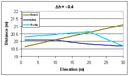
The following graphs show sample outputs from the model while changing the surface water or aquifer characteristics. Overall, the results and graphs were based on the following input parameters (unless noted otherwise):
Ho = 0.5 meters
T = 6 seconds
Slope = 0.05
Dh = 0.4 meters
Mean Water Level = 20.1 meters *generic datum
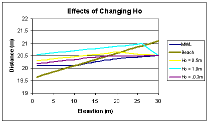
The first graph shows the effects of changing the initial wave conditions.
We can see that as the incident wave height increases, the total wave run-up and setup also increase. With the incident wave height at 1.0 meters, the horizontal distance of run-up and setup increases to near the boundary of the model. This causes the sharp drop off in the groundwater profile. In reality, the effect would be more gradual and would extend beyond the edge of the plot. However, this plot illustrates the general trend that occurs when the incident wave height is changed.
The following graph shows the results from varying the beach slope (0.05 - 0.10).
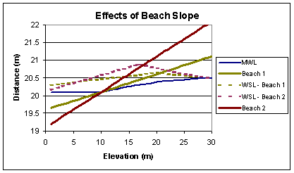
Varying the beach slope has the biggest effect on the surface water profile. With a greater beach slope, the breaking depth is closer to the shore and the wave setup and run-up are greater. Overall, this creates a steeper slope in the surface water, but doesn't have a large effect on the groundwater profile.
The following two graphs show the effects of different aquifer conditions. The first case represents what we may see in natural conditions, where the groundwater generally flows from the inland area and discharges into the surface water body. The second case represents what can happen with development along the coastline. Along developed coastlines, people may install groundwater wells for municipal, industrial, or private use. Pumping of those wells lowers the groundwater table in the area of the coast and can cause groundwater to infiltrate from the lake into the aquifer.