Wave Effects on Coastal Wetlands
Wave Effects on Coastal Wetlands
Abstract Motivations and Objectives Coastal Environments
Approaches to the Issues Results Discussion References
Written
and prepared by Todd Shoemaker
for Professor
Chin Wu, Ph.D.
University
of Wisconsin-Madison
Department
of Civil and Environmental Engineering
CEE 514:
Coastal Engineering
Spring
2000
This
report summarizes and extends the efforts of the University of Wisconsin-Madison
Water Resources Management Programs 1998 project concerning the coastal
wetlands of Manitowoc County, Wisconsin. The purpose of their project
was to evaluate and assess the current conditions of coastal wetlands in
Manitowoc County. My purpose is to apply their results to evaluate
the future effects of Lake Michigan water level fluctuations on these areas.
I will do this by relating equations developed by J.T. Salinder [1997]
regarding erosion resistance of coastal wetlands. His results from
a coastal wetland on Lake Ontario will be compared with my results from
wetlands studied in the 1998 project in Manitowoc County on Lake Michigan.
Coastal
wetlands are an important recreational and functional tool in the environment.
I chose this project to examine why these areas are so important to the
environment and what roles they play in the ecosystem. After exploring
their functions, my objective for this project became clear: to evaluate
the effects of Lake Michigan water level fluctuations on coastal wetlands.
Wave conditions and water depths directly affect the existence of coastal
wetlands. I will evaluate these conditions and offer conclusions
on whether these areas may be decreasing coastal wetland area due to Lake
Michigan.
Coastal Environment of Study Area:
From
Coastal
Engineering, CEE 514 instructed by Professor Chin Wu, a coastal environment
consists of four aspects: land (geology), human activity (past and future
developments), water (levels, waves, currents), and meteorology (pressure,
temperature).
Land:
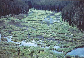
There are several types of landforms and vegetation forms within Manitowoc County. Thirty wetlands, encompassing less than 50 percent of the wetland area of the study zone, are protected through either private or public protection programs. The remaining 27 wetlands are privately owned and not formally protected.
Riverine wetlands, covering approximately 1670 acres, represent the largest
group of wetlands in the coastal zone. Wetlands along Lake Michigan
tributaries are not protected beyond the restrictions imposed by shoreland/wetland
and floodplain zoning laws. A privately owned hardwood swamp in the
southern part of the county covers approximately 457 acres and is the county's
largest single, unprotected wetland. The third group of wetlands largely
unprotected in the county is made up of 142 acres of coastal canyon wetlands.
See the physiographic
wetland types map and the vegetation
communities map for details. Several
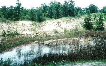
physiographic wetland types, including coastal canyons, bluff seeps, interdunal
and ridge/swale wetlands, show interdependence with coastal processes,
particularly seiche effects [Coastal Wetlands of Manitowoc County, 1998]
.
Human Activity:
The potential for non-destructive human use of the county's wetlands is
very high [Coastal Wetlands of Manitowoc County, 1998]. Uncommon physiography,
high floral diversity, and educational and recreational potential of the
coastal wetlands create an economic asset in terms of tourism and recreation.
However, many of Manitowoc County's coastal wetlands are not adequately
protected from adjacent land use impacts and other threats [Coastal Wetlands
of Manitowoc County, 1998]. Resources should be focused on wetlands
that are most susceptible to threats, particularly those presently lacking
public or private protection programs.
The cities of Manitowoc and Two Rivers are both within the area studied.
Planning must be done carefully to ensure proper urban growth so coastal
developments do not damage the wetlands already in place. While it is difficult
to assign precise dollar figures to the functional benefits of wetlands,
it is clear that replacing wetlands with engineered systems is extremely
costly and often less effective. If this does not happen, recreational
and aesthetic value will be lost and cause corrective measures that will
cost humans even more.
Water:
The five functions of wetlands are (1) flood and stormwater attenuation,
(2) water quality protection, (3) shoreline erosion control, (4) areas
for groundwater discharge, and (5) aesthetic value. Four of the five
deal with the control of surface water, groundwater, or waves from Lake
Michigan.
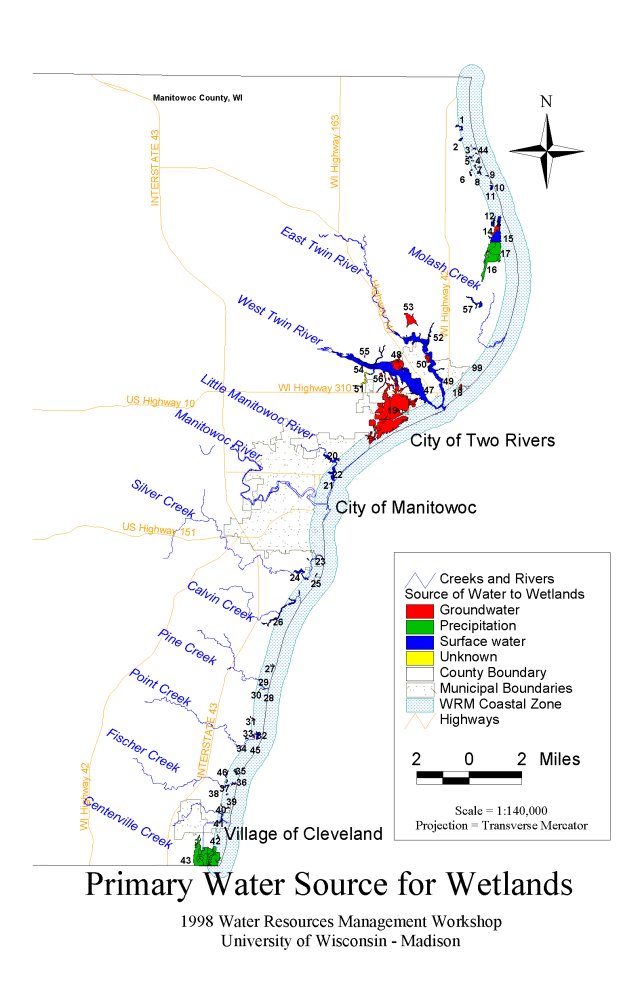
Surface water-fed wetlands have significantly lower plant diversity than groundwater-fed wetlands, most likely due to the effects of road runoff and agricultural runoff in surface water flows. Sixty-five percent of the wetlands assessed receive road runoff and 60% receive agricultural runoff [Coastal Wetlands of Manitowoc County, 1998]. Seriously disturbed emergent marshes and open canopy wetlands are associated with polluted surface water runoff. See primary water source map for details.
Riverine wetlands, coastal canyons, and other wetlands located on Lake
Michigan tributaries provide significant water quality protection for the
lake [Coastal Wetlands of Manitowoc County, 1998]. Sediment released
by upland farming and development practices becomes trapped within wetlands,
which helps to improve the quality of water in Lake Michigan. As
these wetlands become developed or further degraded, their ability to protect
downstream water quality is reduced. See water
quality protection map for details.
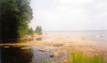
To perform the above functions, wetlands must be adjacent to the coast.
To remain near the coast, vegetation within each wetland has to be strong
enough to resist the erosive forces of the crashing waves. Breaking
wave height, water depth, and maximum horizontal bottom velocity all affect
the growth of vegetation within a coastal wetland. If conditions
exceed the recommended parameters, there is a good chance that vegetation
will not grow and the above processes will not take place.
Meteorology:
This aspect of the coastal environment is just as important as the others
mentioned, especially near Lake Michigan. Storm surges, wind set-up,
and seiches can drastically affect coastal water levels. As described
above, when water levels rise, coastal wetland functionality decreases.
When combined, storm surges, wind set-up, and seiches could destroy an
entire wetland due to lengthy flooding periods or erosive forces.
Within one tributary of Lake Michigan in the study area, water levels rose
as far as two miles from the coast [Coastal Wetlands of Manitowoc County,
1998].
The methodology below follows Salinder [1997]:
Using solitary wave theory:
Breaking wave height = Hb = 0.78d
Max. allowable Hb = 0.6 m
Max. horizontal breaking wave velocity = umax = [g(Hb + d)]^0.5
Max allowable umax = 3.0 m/s
All conditions will be analyzed at breaking wave conditions. Breaking
waves provide the greatest
potential to move sediment and allow the least potential of vegetation
growth.
Salinder also determined
the uplift force to remove a plant from a wetland as:
FL = 0.5CLpgDH2Kdmcos2q
where
CL = lift coefficient = 1.2
p = fluid density = 1000 kg/m3
g = gravity = 9.81 m/s2
D = average diameter of plant stem = 0.004 m
H = wave height, varies with depth
Kdm = depth coefficient = 0.7
cos2q = 1, at maximum wave height
Salinder [1997] performed field investigations on Lake Ontario to determine the actual pullout force needed to remove vegetation. He performed these tests on scripus validus and scripus americanus. Both of these species are present in Manitowoc County wetlands. Therefore, I applied the uplift force equation to conditions in Manitowoc County and compared my results with his field observations.
I approached my analysis two different ways. First, Table 1 shows the conditions of wetlands along the coast of Manitowoc County. The water depths were determined by interpolation between contour intervals on topographic maps of the area. The contour intervals were spaced by 10 feet, so the accuracy of the depths is probably not extremely precise. I evaluated only those wetlands that may have direct contact with Lake Michigan waves, storm surges, or seiches. See locations of wetlands evaluated. The formulas stated above are used in the analysis.
The 1998 Project also extensively studied Fischer Creek, a tributary of Lake Michigan and one of the largest undeveloped properties on Manitowoc Countys coast [Coastal Wetlands of Manitowoc County, 1998]. As a part of their study, they measured the water level in the creek at three different locations. One of these locations measured groundwater base flow, while the other two examined the effects of seiches.
To examine the stability of wetlands surrounding Fischer Creek, I used
the average water depth for base flow over a period of seven days.
For the other two locations, I used the maximum and minimum depths recorded
over the 7-day period. Recorder 1 was placed away from the
channel of the creek; Recorder 2 was located near Lake Michigan along the
channel of the creek; and Recorder 3 was placed in the channel well upstream,
about 1300 feet away from the coast. Table
2 shows the results of the analysis.
Coastal Wetlands:
The maximum allowable breaking wave height and horizontal bottom velocity have already been stated at 0.6 m and 3.0 m/s, respectively, for stable coastal wetland areas. Figure 1 shows the results of my analysis by comparing the maximum horizontal bottom velocities at locations along the coast. One can see that at only one location (#47) does the velocity exceed 3.0 m/s. This is also the only location where the breaking wave height eclipses 0.6 m.
According to Salinders [1997] field observations, removal of wetland vegetation requires 23 N of uplift force for diameters of 0.005 m. Table 1 shows that the forces created by Lake Michigan waves in Manitowoc County come nowhere close to uprooting vegetation. Figure 2 compares the uplift forces determined for selected coastal wetlands in Manitowoc County.
Fischer Creek:
Figure 3 displays the maximum horizontal bottom velocities at the three recording stations within the watershed. According to these results, vegetation should not be able to survive if these water levels are typical of the area; all of these velocities are over the maximum of 3 m/s.
Like the results discussed above for the coastal wetlands, the uplift forces
in Fischer Creek are much less than those that disturb vegetation. Figure
4 shows the forces at the three recording
stations in Fischer Creek.
There is a discrepancy between my calculations shown in Tables 1 and 2 and those determined by Salinder [1997] shown in the field investigations. The equations that Salinder used are relatively simple, so I dont feel that either of us made a mistake. The confusion is probably because Salinder did not clearly define his variables. In the uplift force equation, he did not state if "H" is the breaking height ("Hb") or a different one. The formula states H, not Hb, which is the value that I used. Whatever the case, I am skeptical of the results obtained by Salinder, unless I missed a simple intermediate step.
Based on the results that I obtained, most of the coastal wetlands in Manitowoc County are not in danger of being destroyed due to the current levels of Lake Michigan. Of those sites examined directly on the coast, only one experienced conditions not conducive to a stable wetland. This location, #47, is in an interesting spot. It is located within the Two Rivers harbor. I would assume that this area could become easily inundated in a storm surge or seiche due to the narrowing harbor. Breaking waves and horizontal bottom velocity are probably not large concerns at sites #47 and #48 because of their location within the harbor. For those reasons, I am also skeptical of their susceptibility to erosive forces as the equations predict.
Within Fischer Creek, I highly doubt that there are breaking wave heights of 0.7 m or 0.8 m, or even waves at all. However, the values of bottom velocity and uplift forces may be valid, but only if the stream flows quickly enough. The results and figures do indicate an increase of all conditions during periods of high water. This reinforces the importance of understanding seiche and storm surge effects, especially on inland tributaries.
In closing, more parameters need to be addressed to properly assess the
impact that Lake Michigan water level fluctuations have on coastal wetlands.
These equations and methods may be a beginning, but what about wind, precipitation,
refraction, diffraction, and even other conditions that havent been accounted
for in these simple formulas? More information (and time) is definitely
needed to perform a complete analysis of all factors affecting these precious
areas within our state.
The Coastal Wetlands of Manitowoc County. 1998 Water Resources Management Program, University of Wisconsin-Madison.
University of Wisconsin-Madison Map Library. Topographic maps for water depth data. 1954, 1973, 1978.
Silander, J.T. Modeling Coastal Wetland Stability. Canadian Water Resources Journal, Vol. 22, No. 2, 1997, pp. 197-212.